


If you’ve read previous posts, you’ll know I’m doing 50 Things before I’m 50….this is one of them. This is my account of my epic adventure completing the 15 Trigs.
It was an adventure requiring me to dig deep into my physical and mental strength. Reflecting the shear scale of this adventure, this post is an epic…so grab a brew and read on.
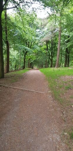
The short story if you’re only a tiny bit curious is that I did a long walk, visited 15 trig points in the Peak District, and it took a long time.
I was supported by my partner, and together we covered 91.44km with 3089m ascent. Now onto the longer version if you want to read all about the magic, the pain, tears and courage.
In August I will be 50 years old. Last year I set out 50 things to complete before then, as challenges for myself physically and mentally. Some things are small, some are massive. This falls into the latter category.
I’ve watched others complete the 15 Trigs, and I’ve supported my partner Tim on one of his rounds. I knew it was going to be epic however I did it.
My intention to ‘do the 15 Trigs’ one day has been in mind for a good few years. The ideal time of year to do it is April or May, before the bracken and heather get so overgrown it makes some sections horrible under foot. On adding this to my 50B450 list I knew I needed to do it in around May 2023 ideally.
I’ve pondered doing it solo, or with Tim, as a group thing or just me and a friend. In the end a friend came on board and we did a few walks and runs in the hills together. We were both up for it. Superb. Then training tailed off over winter and a few months passed without doing much towards the 15 trigs at all. In some ways it was just too big to think about. Too far in the future. It got round to April and I realised we’d not had any hill days for some time, nor had we spoken about doing it, so we got together and had a good honest chat about whether either of us were ready to attempt the round.
The result of that conversation was that we’d just give it a go on not a lot of training and just see what happened. What was the worst that could happen? We could bail at any point and were both OK with that. We’d spoken about what we’d do if the other couldn’t carry on, but hadn’t really discussed how the weather might affect things other than neither of us was going to set off in rainy/wet or too hot conditions.
We’d got 16/17 June earmarked for ‘the day’. There’s been a period of really settled weather, not too hot, no rain and little wind. It was looking good. At the start of this week I got on weather watch. My heart sank. Rain and thunderstorms forecast from 15th. Bugger. Pushing the round into July was going to add the bracken and heat variables into making it super hard. Tim joined the conversation and on Tuesday simply said….”why don’t you do it tomorrow?” to which I replied…because Sam isn’t free. Other dates in the next week also didn’t work for us. Exchanging messages Sam ended up with her suggesting I did it with Tim and after much consideration from me I decided to go for it with Tim.
Here’s the facts:
Distance: 55 miles/90km
Ascent :10,000ft/3000m
Rules: visit 15 specific trig points in the Dark Peak area of the Peak District. There’s no specific route to follow, except one part which you aren’t allowed to use a road. Additionally, this route includes a visit to (and the traditional start point) the Sportsman Pub in Sheffield. Those from the Manchester side of the Peak District tend to start or include the Royal Oak at the bottom of the Snake Pass as the start/end. We would be passing the Royal Oak on the way back home, so our start point was home.
Trig points (in order from our starting point in Glossop: 1. Cock Hill, 2. Higher Shelf Stones, 3. Alport, 4. Outer Edge, 5. Margery Hill, 6. Back Tor, 7. Emlin, 8. Rod Moor, 9. High Neb, 10. Win Hill, 11. Kinder East, 12. Brown Knoll, 13. Kinder Low, 14. Sandy Heys, 15. Harry Hut.
This is an anytime event and to be classed in the fell running world as a ‘successful’ round it needs to be done within 15hrs. For me, a round in 15hrs would never be a possibility, even with some running. I’d weighed up all the variations of doing a sub 24hr round, if sleeping somewhere would be a necessity or if outside support might be needed. I’d also wondered about doing the 90km over 2 days with an overnight camp might make it a fun adventure…but discounted this as the extra weight needed to carry camp kit would mean an even slower, more tiring 2 days. My aim and a successful completion would be finishing, doing that under 24hrs would be mind-blowingly fantastic.
In less than 24hrs from deciding we were doing it, Tim and I were ready to go. It was around 4.45pm on Wednesday when we locked up the house. We had a friend arranged to feed the cats (massive thanks to Mark) the next morning and we set off. Bags stuffed with as little spare gear as we could get away with and plenty of (too much probably) food.

First up, an easy well known path to Cock Hill (#1) and then across good trods to Higher Shelf Stones (#2). A route we both know well so was easy going, chatting away and nicely pleased to be up on time by nearly an hour at trig #2. My predicted timings for each trig point were really rough and based on around 4km/hr. I’d not included any variation of pace for ascending or descending, or the terrain underfoot which was going to vary from tarmac sections to waist deep heather bashing and bog hopping. Nor had I factored in slowing down in the latter stages as we tired, or for the time needed to ensure navigation was spot on. So however much we were pleased on being ‘up’ on time, I knew we’d be wise to hold back on actually knowing if a sub-24hr was feasible until literally the last few miles after leaving the 15th trig at Harry Hut. And that was a long, long way off.

Our plan was to eat little and often, and at least something by or in between each trig point. And so we set out well with our mix of sweet and savoury goodies. Sipping water as we went also kept up hydration and we did extremely well on this throughout the route. Having no idea what sort of food I’d be wanting we’d got a good variety packed – from haribo, cookies, chocolate, fruit bars, apple chunks, apricots & salted peanuts, pork pies, cooked sausages (they really went down well), cliff bars, milky-way protein bars and a couple of caffeine gels. There was also a flask of coffee which we’d debated taking….this is one thing I’d highly recommend on overnight adventures, it went down so so well.
At Higher Shelf Stones I politely asked for some guys to move over so I could have my photo taken – one of Tim’s jobs was to ensure I got a photo at each trig. I’m sure they were amused by the super quick turnaround – snap taken and we were off again, heading into the moorland past the B29 plane wreck and across the well defined path to Hern Clough. The ground was incredibly dry and I could already tell my feet were going to be a concern as the hard packed peat had no give in it whatsoever. We were using sticks already as they help to absorb some of the weight and reduce the force going through your legs, especially on descents. I knew they’d be super helpful in the later stages, but it was already evident they were helping with small drops and pushing up inclines.

I was already feeling the benefit of Tim being with me as we traversed around the Alport valley. I’ve not been on this section many times and would have needed to be map checking to ensure we left the path at the right point. Tim however knows this line well and we were soon climbing up before Miry Clough onto the open moorland. Some heather bashing and we picked up the clear trod to Alport trig (#3).

It was now around 7pm, so we had a clear 2.5-3hrs of daylight/twilight ahead of us. I was feeling apprehensive of the coming darkness, and in some ways I wish we could have set out earlier so we could be across and beyond Emlin trig and the most challenging nav section in daylight. The only other way to avoid that being in the dark would have been to hang around at home until maybe midnight and done the first 3 trigs on paths we know in the dark, going into dawn on the harder nav bit. Hey ho, I’d said to myself, it’s just the way it is so suck it up!
From Alport there’s a clear good path along the moors and valley top to Birchin Hat, turning sharp left down a wide path into Fagney Plantation. The last bit gets super steep and our walking sticks were invaluable at helping with stability. The next section on the road is paradoxically easy (under foot) but hard as you’re on tarmac and it seems to go on for absolutely ages until you reach the end of the road at the north of Howden Reservoir at Kings Tree. It’s only around 3.5km until you get to the old Packhorse Bridge at Slippery Stones but it feels so much longer. We were at Slippery Stones around 8.30pm, and wondering if we’d get across the bog monsters on the moors between Outer Edge trig and Margery Hill before it was dark. Tim has run this section a few times on various races and challenges, and assured me the peat bogs are actual man-eating monsters you really don’t want to fall into.
With this in mind we started the ascent up Broadhead Clough and the short out and back to Outer Edge trig (#4) with purpose. Tim had needed to put on a blister plaster at the start of this climb so concerns over feet health were on my mind. I couldn’t work out if I had a hot spot (start of a blister) or not, but the sensations kept going so I ignored it. There was bound to be some (a lot) of foot discomfort from simply being on our feet for so long. At Outer Edge trig light was starting to fade noticeably but torches still not needed. It was around 9.15pm and only a short 2km section to Margery Hill.

Having pushed up Broadhead Clough we were stoked to get to Margery Hill (#5) in early twilight, at around 9.30pm. Still eating well, still drinking, all good and we’re around a quarter of the way there. Will I be able to complete this?? The only thing to do was to focus on getting to the next trig point. Don’t think about the whole journey. One step at a time and you’re making progress.

Navigation from Margery Hill to Back Tor isn’t straight forward. There’s the potential to miss decent trods around Featherbed Moss/Round Hill, and end up in a whole world of grough pain, crossing seriously gnarly ups and downs, being turned around as compass bearings are hard to follow. I was totally relying on Tim’s knowledge and skills to get us there. I really was taking a back seat on the nav front, and feeling guilty about it as well as incredibly relieved I wasn’t responsible for the ease as which we crossed this moorland as darkness was falling. Tim did the most amazing nav, finding the lines, and getting us to the main path to take us south to Back Tor. I’m so very grateful he was with me here. I know without him this, and the next section, would have been much more demanding on me mentally and physically and would have taken so much longer.
So as darkness fell we were heading approx South-East towards the main path to Back Tor. I briefly used my torch and at some point realised Tim didn’t have his on so I turned mine off to see if I could see OK. It seemed I could, so left the light off. Once on the flagstones along to Back Tor there was enough twilight and we plodded on in fading light. Back Tor seemed a long way, in fact the whole leg from Margery Hill is around 7km and took around 1.5hrs.
At Back Tor (#6) the time was just before 11pm. Fully dark and the temperature had significantly dropped, the wind whipping around us much stronger than had been forecast. I was seriously concerned I’d brought the wrong gloves and had to blow warm air onto my hands to stop them becoming numb. Walking with poles is great, but holding them with exposed thin-gloved hands wasn’t fun. So annoying to have loads of warm gloves at home but not packed them!

We had a very short kit sort at Back Tor before retracing our steps northwards for a couple of kilometers, until the point you have the leave the lovely well defined path and enter the horrific heather bashing for around 3km to get to Emlin trig. I’d been scared this section would break me. We’d got around 33km done, which would be my longest distance for a long time, but still have 60km to go. Constant high knee lifts to get through deep heather could have properly wiped out my chances of continuing or finishing as it tires your legs and hip flexors far more than just walking. It’s a movement your legs aren’t used to. There’s also the real risk of falling into hidden dips and holes and the potential to twist ankles is high. It’s fair to say stress levels were on full alert across this section.
With Tim on high nav alert I just focused on one foot in front of the other. Two steps done and another metre of distance travelled. I counted steps for a while. I kept checking in with Tim to keep him on the nav. He was using map and compass to get us across Cartledge Flat and on to Wet Slack Ridge before going eastwards to Emlin. At short regular intervals the map was checked, lights in the far distance noted and aimed for. We seemed to be constantly side tracking to bash through the lowest heather we could find, sometimes mown but not totally flattened, sometimes painfully hard and burnt at calf level. Our calves have the wounds to testify that this section was not fun.
I felt constantly turned around direction-wise on this, totally reliant on Tim and kept having to nudge myself that the only way through was to keep moving. I’m grateful there were sections of heather that weren’t waist deep, it no doubt helped to make reaching Emlin easier….but far from easy.
Around 1.5hrs after leaving Back Tor trig we reached Emlin (#7) at nearly half-past Midnight. Tims nav was spot on. Looking at the line now on strava it’s evident his nav was excellent. Heading down the hill from the trig was more heather bashing fun. I was sure there should be a quad track or trod for the line of grouse butts but hadn’t the energy to start map reading in minute detail and left it to Tim. We were going down which was correct, and I had felt tired and discombobulated by direction for the past 3+ hours so left him to it. I think at some point I said we might need to be over towards what is Emlin Dike…and eventually we found the track down to the gate. Again, looking at strava the line Tim led us on was fine, just off the track but certainly in the right direction.

At the gate we had coffee to give us a boost for the next long section across the few ups and downs to Rod Moor. I’d recced this section with Sam only the weekend before, so it was fresh in mind, though it being dark, tiredness and lack of sleep were causing me to doubt the turns. This whole section, around 7km was a bit trippy. Walking so late in the night isn’t something I’ve ever done fresh, let alone after being awake for maybe 20hrs. Paths were walked on, gates passed through, a deer almost spotted near Dale Dike reservoir, uphill climbs through trees, and scrambling through rocks and over farm fields all passed by in a spacey-haze. It felt great to not need a map, and know what was coming up ahead. I think the whole section from Slippery Stones to the gate after Emlin had felt extra hard because I didn’t know it. I had no real idea of directions, distance, conditions under foot, having never walked on any of it. That felt perturbing. But knowing the Emlin to Rod Moor and on to the pub section was comforting. I could focus on more than just each foot step.
Walking up past Crawshaw Farm was a long drag up the track. I was looking forward to dawn coming in a few hours. There were some horses come say hello to us along side the track and then onto the moorland a whole flock of sheep eyes glistened in our torch beams. I was glad I knew they’d all be there! A short section of heather bashing and we reached Rod Moor trig (#8) at just gone 2am. The lights of Sheffield glowed on the clouds and it felt like a big chunk of the route was now behind us, we were almost at the halfway point and would soon be heading westwards towards home.

The road along Rod Side seemed stretched out-longer than I thought. Doubting if I’d missed the turn. Eventually we both recognised the turn right onto Onksley Lane and headed down towards the A57. Easy under foot but knees starting to grumble, feet definitely sore and the hot-spot still coming and going. Walking down the A57 was a bit surreal…fully in the middle of the night I wondered what the people would think of us in the few cars that passed by. Across Rivelin dam wall and then a steep climb up through the trees at Fox Holes Lodge and we were eager for daylight to come now. My headtorch was beginning to properly annoy me, the band rubbing my ears, the light pressing on my forehead. The lack of sleep was exacerbating every little niggle and it took some will-power to switch off the negative thoughts. There was still a long way to go, the pub being pretty much half way round, so there was no point listening to Chimp Fred in my head who was trying to sabotage my adventure.
Finally the steep woodland gave way to the back of the wrong pub, through the car park and a short leg in the wrong direction to the Sportsman pub. I’d contacted the pub to check opening times a while back, before I knew what our potential arrival time at the pub would be. Needn’t have bothered, as they obviously weren’t going to be open at 3am!!! Thankfully I’d learnt there’s a water tap outside so we replenished our bottles, sat down for 5 mins to sort kit, then took a photo to add to the album before starting a long section of road.

Next trig point is High Neb and officially we’re on our way home. This leg is about 6.6km, either on tarmac along Redmires Road or a rough track to Stanedge Pole and across to Stanage Edge. In the end this section, whilst feeling long and interminable only took us 1hr 22, getting to High Neb (#9) around 4.30am. We’d crossed from deep twilight into almost daylight so headtorches were taken off somewhere along the way. The wind hadn’t really eased off and Tim was feeling the cold. Surprisingly my body temperature felt OK but hands still kept being pretty cold. I’d be thankful of the sun when it reached us. Food and drink were still being taken on, though it was harder now to be enthused by actually eating. I knew I had to but my mouth wasn’t enjoying the process any longer.

I’d hoped we’d get a stunning sunrise, but like the sunset last night which was hidden mostly by cloud, dawn broke to cloud and just a gradual lightening of the sky. It absolutely felt great to be back into daylight, but I’d heard of other people getting a real boost from dawn on overnight adventures – this didn’t happen for me and it just kind of happened unremarkably. At the time I didn’t think this, I’m only just reflecting on this now afterwards as I write.
Getting past High Neb was a good point. I reckoned I knew all the nav to get us home and was really familiar with a lot of it so could switch off from the deep nav concentration. From hereon-in it was about shutting out the negative head, ignoring the ever increasing desire to just stop, and actually focusing on enjoying the journey and being amazed I was still moving. I was starting to feel really chuffed to get to this point. By Yorkshire Bridge I would be into new territory for me physically. I’ve done a couple of ultra races before, but my max distance was around 55km. Yorkshire Bridge comes at around the 60km point…so who knows how I’d cope from there. I was excited by the prospect of actually finishing, though there was still a lot of ground to cover.
After leaving High Neb there’s a short down-climb section off Stanage Edge and through the bracken to join the road at Dennis Knoll. Each step off a rock onto uneven terrain was really hard, I was looking forward to being on tarmac and the ‘ease’ of not having to think about how or where to put each foot on each step taken. The road section here goes on for around 4km, mostly downhill, so the discomfort level physically and mentally was growing with each step. It seemed to take for-ev-er. I was annoyed by the length of this section but once again, knew the only way to get past it was to keep moving. My desire for tarmac was now replaced with a desire for the lumps and bumps of moorland and I was looking forward to going uphill, as descending was the more painful of choices.
By now my legs, feet, knees and, well pretty much all of me wasn’t comfortable. Mentally I was still with it and alert. I kept checking in with myself….was there any ‘real’ pain? Was the discomfort just annoying or actually something to be concerned about? Was the soreness any worse than at the last trig? I could keep check and felt I was still good to keep going. The pains weren’t going to go away even if I sat down for half an hour and it would only delay getting to the end and being able to stop moving.
After what felt like hours (which in fact was less than an hour) we got left the tarmac behind for the last time until we’d be on the last few kilometres to get home. Next came the brutal climb of Parkin Clough. Steep doesn’t seem harsh enough to describe it on a day you are only going up Win Hill. But 60km into 90km it’s horrible. I’d had a good talk to myself and just took it one big step up at a time, one tree passed at a time, one more metre climbed up is one metre closer to the next trig. The trees started to thin out and then after a good half hours climb, at nearly 6.15am we’re at Win Hill trig (#10). I’m amazed we ascended this section so quickly to be honest!

The views from here were amazing….you’ve got all of the Edale and Hope Valley, the Great Mam Tor ridge, Ladybower, towards Sheffield and more. We could see parts of the route we’d done, and what was to come. And for the first time home was feeling close….just Kinder Scout to travel over and 5 more trigs. I felt we were more than two-thirds the way through, but held off any celebrations. The only time to celebrate was to reach home and sit down.
From Win Hill things got hard. Like really hard. It was now about ticking off smaller sections than ‘just get to the next trig’. Mentally I was starting to break down sections. So from Win Hill we had to get to Hope Cross, then Crookstone Barn, then to the top of the climb onto Kinder Plateau, then Madwoman’s Stones (after the stones that aren’t Madwoman’s Stones), then the big isolated stone and then…only then would we get to the trig. Mentally each stage accomplished became all that mattered. While I had a bit of paper with the distances on they became less meaningful along Kinder.
In terms of time, my rough predictions had us at Win Hill for 10am. We were almost 4hrs ahead so questions of a potential sub 20hr round were quietly considered. I’d only know if that was a possibility after leaving the last trig, because from here my body wasn’t going to move any faster than it wanted. My body was in charge, so while I was alert and mentally strong, the body was seriously starting to break.
Comfort came on the next section from knowing the path well. I could describe Win Hill well as I lived in Hope for a few years as a kid. It helped to know what the path was like, how long it was to the next turn etc. I laughed as we passed the turn down to Twitchill Farm, so grateful we didn’t have to descend those steep fields. With Hope Cross behind us the climb up past Crookstone Barn began. Going uphill was infinitely more comfortable than down so I felt happier here. I’d done a solo recce from Bamford to home only 3 weeks ago and knew there was around 30km to go.
At some point around here my watch (which I’d annoyingly had to keep charging as we walked) decided to stop recording with no notice. It was only because I was wanting to know how far we’d done that I realised. I’m totally baffled by this, because to stop an activity means you have to 1. unlock the watch, 2. press stop, 3. press save, 4. press done. I did none of those, so the watch glitched and I’d lost the recording. Thankfully Tim’s watch was still well over 55% charged and working fine…and continued to do so. I’d have his gpx.file to upload. Annoying as it was, having something different to think about was a good distraction for a while!
So, climbing up up up got us onto Kinder Scout plateau and into the middle of it on trods past Madwoman’s Stones and to the trig point with various names…to me known as Kinder East (#11) at 7.50am. Just over 1.5hrs from Win Hill so still moving ok and a decent pace, but slowing a little. The pace was going to be what it was, and I knew the edge path was going to be interminable. It undulates and is rocky and flagged in places so there’s a constant need to be stepping up and stepping down, going round boulders or up and over, side-stepping feels annoying as it adds time. And all the while along this long long section I’m looking out across Edale Valley, stunned I’m here. In awe as my physical ability. In awe at how far we’ve travelled. Proud of my mental strength to keep me moving. And absolutely full of gratitude to be sharing this full-on Type-2/3 adventure with Tim. What a star and ultimate supporter he is.

Early morning on Kinder and there was starting to be a few more people around. I recall noting on Win Hill that we had barely seen anyone at all since leaving home. There’d been 3 guys at Higher Shelf Stones, a few people around Howden reservoir and I’m sure no-one else until Win Hill…where about 1 minute after saying this a woman ran past us!! We’d past a wild camper near Crookstone Knoll and contemplated knocking on to see if they had coffee going…we didn’t, it would have meant scrambling down and back up a short way! Side trips even for coffee weren’t going to happen.
Kinder East to Brown Knoll is one of the longest sections in terms of kilometres, and it was long. Approaching around 8km in distance but felt way longer. The wind had really picked up and was super annoying. Tim was chilled and starting to not be able to generate enough heat for himself, though I didn’t know it at this point. Even though the sun was out as we headed westwards, it was chilly and I kept having pangs of regret for not bringing warmer gloves.
At last we got on to the 3km out and back section to Brown Knoll, hitting the trig point and stepping up onto the concrete base too a big effort and felt like a massive step….it was 9.37am as the photo was taken at Brown Knoll trig (#12). A sub-20hr might be possible, or perhaps not. But we felt sure a sub 24hr was going to happen unless some of our wheels fell off further.

I kept reminding myself why I was doing this ridiculously long and hard challenge. I’m not sure I’ve voiced this before, but I was doing it because I can. Because I didn’t know if I could. Because I knew others who’d done it, so why not me. Because in reality I’ve never started something that I didn’t deep down know I could finish. So I was doing it because I didn’t know if I actually could do it. Even the ultra races and marathons I’ve done, that I knew would be hard, I never really doubted I’d finish. The hardest challenge I’ve done before was the Bryce Canyon (Utah) 50km race (actually 51.5 and the 1.5 makes a whole world of difference!) and I knew I’d finish that. There’s something about not knowing what your breaking point it, not knowing what you can actually achieve and what the point is when it’s too much for you physically or mentally. I’ve never really tested this before. Well I was 100% testing it now.
So, the twelfth trig behind us and a short leg up to Kinder Low. Another ascent up past Edale Rocks was a relief from descending and cherished as the next leg to Sandy Heys was going to be hard. More rocky-ness to overcome which was now ridiculously hard on the body and the mind. I’d become aware Tim was really struggling so started to be able to ignore some of my discomfort and focus on checking in on him more. I think I’d naively not considered what would happen if Tim started to struggle. I know he’s not unbreakable, but I’d not thought he might truly suffer so badly while supporting me. There was some guilt creeping in that I was making him suffer for my adventure.
Kinder Low (#13) reached and a big effort to scramble up onto the boulder plinth it sits upon. I was genuinely scared once up there that I might not get down, but heard a friends voice in my head to ‘just do it, don’t think’ (thanks Sam). It was now just after 10am and we had perhaps 12 or 13km to go. At the pace we were moving, and likely to slow down, a sub 20 was unlikely. To be frank my brain had stopped being able to compute calculations and it was just going to be whatever time it would be.

From Kinder Low our conversations were short, functional….’you ok?’ …’yeah’…..’drink’…..’I am’….sort of exchanges. Tim was starting to stumble a bit, at some point he mentioned being very tired, drifting into sleep as he moved. We got to Kinder Downfall and were simply focused on one step, next step, left, right….keep moving. There was a little confusion and we almost missed turning up to get the penultimate trig. I’d pretty much switched off. I knew we had to go to Sandy Heys but was zoned out. Thankfully there’s a fence line to jolt the brain and push us to turn up the moorland leaving the path behind us for a short while. I’m surprised it only took us about 45-50mins to get to Sandy Heys trig (#14), feeling slightly giddy that I knew I’d definitely finish. The waves of hunger and spaced-out nausea had been with me a while, but now the doubt of ‘if’ I’d finish were gone. There was no point to bailing now. It might not be pretty and I was certainly going to be in a world of pain for a good while yet, but I knew I would finish.

We’d chatted at various points about bailing, not with any real intent, just more like the theoretical conversations you have. Since getting on to Win Hill the most logical way to get home was to keep walking as all other options to bail would involve sitting and waiting for some form of transport and getting very cold and stiff with a long journey to still do. Now were were virtually in sight of home, so there was 100% no point bailing. Just keep walking. Pride for what I was accomplishing was filling me, I was emotional but kept pushing those thoughts away. I still had a long way to go in an exhausted body on the edge.
A little more walking on the edge path past the path down Sandy Heys…Tim cut us a tiny corner on a grassy trod which was grateful for. Each time you save a metre or you go round a rock instead of stepping on it you really appreciate it. It feels like a mini victory.
The next section had been playing on my mind for quite a while. The steep rocky uneven and gritty descent off the end of Kinder. I don’t like it at the best of times. With 80km and 3000+m ascent in my legs it was going to be horrible. Tim up ahead, I urged him to be really slow and careful. Focus on one step down, move sticks forwards for support, one step, move sticks. Eventually we reached the bottom. Tick. That’s that done safely. Phew! I was so relieved we got down without any stumbles.
Onwards and up to Mill Hill. I’m sure I was rambling a little incoherently by now but Tim was too polite/too out of it to bother commenting. The flags along to the final turn to Harry Hut were seriously hurting my feet. I realised along here that my feet felt squishy and for the first time allowed myself to consider that I might have horrific blisters on all the soles of my feet. Nothing to do about it but keep moving. I got emotional that we could see Glossop. It – the finish – home – was in sight. The place where we could stop moving was literally only a few kilometres away. I only stopped the tears coming because it would waste energy that I needed for the 5km from the last trig.
An internal happy dance was danced as we got sight of Harry Hut trig. Moving closer to it step by step…and finally the last little but of uphill to the trig. We’d done it – but not got home yet – trig #15 was in the bag. Flipping heck. What a massive accomplishment. It was 11.52am on Thursday. Still not 24hrs since we left home at 4.45pm on Wednesday.

But the celebration had to wait. With the trig photo taken we continued the slow descent down the moor, past Wormstones and still with a brutally strong wind. Even when it was on our backs it wasn’t adding any help, just really annoying. The road was upon us and now tarmac plus 3 fields and a short 150m of road to get home. Breaking this down into tiny sections that got smaller was the only way to keep moving. Just get to the gate, the next tree shadow, that next lamppost. Eventually we crossed the A57 around 10 or 11hrs after we’d crossed it at the Sheffield end of the route. In the final field we saw someone we knew but didn’t have the energy to wave or speak…Tim was almost asleep walking and I was in agony. We just had to do 400 more metres….and we did. We made it. And we could stop moving.
The 15 Trigs are DONE. Another of my 50 Things ticked off. Distance covered was 91.44km and 3089m ascent in 20hrs 20mins.
Average pace was 12:42/km which is incredible. I know we slowed after leaving Win Hill but the kilometre splits are fairly even throughout. I’m astonished, that we didn’t slow down significantly. That really is down to Tim’s experience on long distance challenges, and his stamina, his strength to pull me along. I know without Tim there I wouldn’t have completed this in this time. I’m fairly certain I wouldn’t have finished at all.
What followed arriving home is a bit of a blur. Getting in the house, dumping kit where it fell or was taken off, having a drink and some food I think. My main priority was to change into comfortable clean clothes so I had the briefest of showers to clean off most of the muck, that was after the massive effort to climb our two flights of stairs!!! I had an impressively big blister on my left heel – causing the most excruciating pain when I popped it. It’s still so so painful two days later, I’ll be in flipflops for a good few days. Tim had a shower and fell into bed but was virtually asleep before he got horizontal. I lay down too and slept deeply for maybe 3hrs, waking very confused and stiff, feet hardly able to bare being stood on.
It’s two days after finishing. I’m understandably tired, weary and a little shocked at having completed the 15 Trigs, what has always been a challenge I thought ‘I’d never be able to do’…..I have. My body is stronger than I think. However, I have no desire to repeat the discomfort I’ve inflicted on my body. Though it is good to know I didn’t sit down and stop, call Mountain Rescue and need help to get off the hill. On one side the whole the walk wasn’t enjoyable because of the discomfort, it was a challenge to see if I could do it. On the flip side it was delightful to spend time with Tim doing the challenge, soaking up the amazing area we live in, seeing magical moments before us as we ticked off each trig point. I did keep reminding myself as we travelled to note magical things – the hairy caterpillars, dew on the grass, sunbeams breaking through the clouds, the grass dancing in the wind, the sounds of grouse…and the family of grouse and chicks we disturbed in the dead of night that all took flight…except the 2 little ones who sat and stared at the weird humans wandering around the moors. There was magic, and there was pain, I know the magic memories will persist longer. In the future I think I’d rather do challenges to see if I can do them but know they will be enjoyable and not push me over into such pain!!
I feel emotional every time I think of what I’ve done. Tears well up as I think how far I’ve travelled on this adventure. It’s a massive achievement and I’m incredibly proud of myself. I’m proud of Tim too, for the journey wasn’t easy for him either. My gratitude for Tim’s support before, during and after this epic adventure is deep.
Adopting better habits and thought patterns can help us accomplish far more than we feel is possible. Coaching conversations are an opportunity to learn about yourself and your experiences. You have the space and time to explore what keeps you stuck, unfulfilled and not living aligned to your values. If this sounds like something you’d like to look into take a look at the Services I offer or get in touch to arrange an initial free and informal chat.

Pingback: 50 Things Before I’m 50 Challenge: Update 2 Copy – Lynne Taylor Coaching
Absolutely epic achievement Lynne, and an epic write up too, I loved reading this x
Thanks so much Clare, still finding it hard to believe what I did!!